| Magnasoft Walk-In Interview 2026 |
LiDAR Engineer and HD Mapping Specialist Jobs
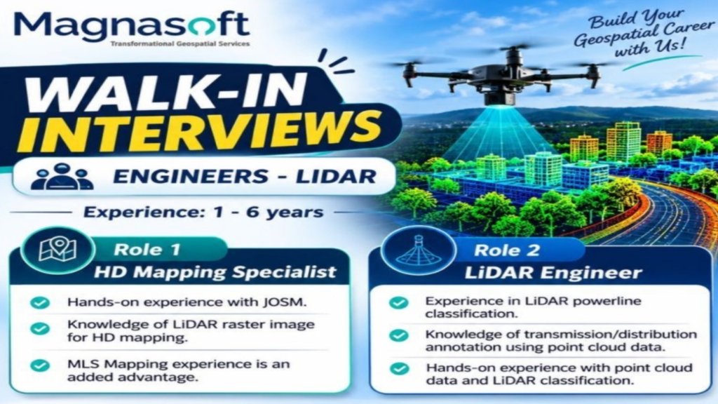
- Magnasoft, a company specializing in transformational geospatial services, is conducting walk-in interviews for experienced engineering professionals in LiDAR and HD mapping.
- Candidates with 1 to 6 years of relevant experience can explore opportunities for the positions of HD Mapping Specialist and LiDAR Engineer.
- The walk-in interviews are scheduled from 11 November to 13 November 2026, between 10:00 AM and 5:00 PM.
- Applicants with hands-on experience in JOSM, point cloud data, LiDAR classification, HD mapping, and powerline classification may find these roles relevant to their skills.
- If you are looking to build your career in geospatial technology, mapping solutions, and LiDAR data processing, this recruitment drive may be worth considering.
- Read the complete details below, including job roles, required skills, interview dates, registration information, and frequently asked questions.
| 1. Magnasoft Walk-In Interview 2026: Overview |
Magnasoft is inviting eligible candidates to attend walk-in interviews
- for engineering roles focused on LiDAR and high-definition mapping.
- The recruitment drive is intended for candidates who have practical experience in geospatial data processing and related mapping technologies.
a. Recruitment Highlights
- Company Name: Magnasoft
- Industry: Geospatial Services and Mapping Technology
- Recruitment Type: Walk-In Interview
- Job Roles: HD Mapping Specialist and LiDAR Engineer
- Required Experience: 1 to 6 years
- Interview Dates: 11 November to 13 November 2026
- Interview Timings: 10:00 AM to 5:00 PM
- Registration Mode: Online registration
- Interview Location: Refer to the official map link provided below
b. Who Can Apply?
- Candidates with 1 to 6 years of relevant professional experience in LiDAR engineering, HD mapping, point cloud processing, or geospatial annotation can consider applying.
- Applicants should review the specific requirements for their preferred role before registering.
- Practical knowledge of mapping tools and LiDAR classification processes may be particularly relevant to this recruitment drive.
c. Why Consider a Career with Magnasoft?
- Geospatial technology supports a wide range of applications, including digital mapping,
- infrastructure planning, transportation, utility management, and location-based solutions.
- Working in this field can help professionals develop technical skills in spatial data processing, mapping workflows, and the interpretation of complex geospatial information.
- Candidates interested in building expertise in these areas can explore the available opportunities at Magnasoft.
| 2. Available Job Positions at Magnasoft |
The recruitment drive features two engineering positions.
- Candidates should evaluate their experience and technical skills to determine which role best matches their professional background.
a. Role 1: HD Mapping Specialist
- The HD Mapping Specialist position is suitable for candidates interested in high-definition mapping and geospatial data processing.
- HD mapping involves creating detailed digital representations of roads, infrastructure, and surrounding environments.
- Such mapping solutions can support applications that require accurate spatial information and detailed environmental data.
- Candidates with relevant mapping experience and familiarity with geospatial tools may consider this position.
- Applicants should confirm the complete job responsibilities and additional requirements with the recruitment team.
b. Role 2: LiDAR Engineer
- The LiDAR Engineer role focuses on working with point cloud data, LiDAR classification, and related mapping activities.
- Candidates applying for this position should have hands-on experience with LiDAR data processing and classification techniques.
- Knowledge of utility infrastructure annotation and HD mapping workflows is also relevant to the skills listed in the recruitment announcement.
c. Experience Requirements
- Magnasoft has specified an experience range of 1 to 6 years for these opportunities.
- Candidates should ensure that their professional experience aligns with the advertised range and the technical expectations of the position.
- Relevant project experience can help demonstrate practical knowledge during the interview process.
| 3. Skills Required for Magnasoft LiDAR Jobs |
The recruitment announcement
- highlights several technical skills for candidates interested in these engineering positions.
a. Hands-On Experience with JOSM
- JOSM, or Java OpenStreetMap Editor, is a mapping editor used to create and edit OpenStreetMap data.
- Candidates with hands-on experience using JOSM should be prepared to discuss their familiarity with mapping workflows, editing tasks, and geospatial data handling.
b. Knowledge of LiDAR Raster Images for HD Mapping
- Knowledge of LiDAR raster images for high-definition mapping is another listed skill.
- Candidates should be ready to explain their experience working with LiDAR-derived data and how it can contribute to detailed mapping projects.
- Familiarity with raster data interpretation and mapping applications may be useful for discussing relevant project work.
c. Mobile Laser Scanning Mapping Experience
- Mobile Laser Scanning (MLS) mapping experience is mentioned as an added advantage.
- MLS technology collects spatial data using laser scanning systems mounted on moving platforms.
- It can help capture detailed information about roads, buildings, utilities, and other surrounding features.
- Candidates with MLS mapping experience can highlight relevant projects and explain their contributions to data processing, feature extraction, or mapping deliverables.
d. LiDAR Powerline Classification
- Experience in LiDAR powerline classification is one of the technical requirements highlighted in the announcement.
- Powerline classification involves identifying and categorizing electrical infrastructure features within LiDAR point cloud data.
- Candidates with relevant experience should be prepared to describe the tools, workflows, and quality checks they have used in previous projects.
| 4. Transmission and Distribution Annotation Using Point Cloud Data |
The recruitment announcement also highlights
- knowledge of transmission and distribution annotation using point cloud data.
a. Understanding Point Cloud Data
- Point cloud data consists of three-dimensional points representing the surfaces and structures of objects captured through technologies such as LiDAR.
- These datasets can be used to analyze infrastructure, identify objects, and create detailed spatial representations of real-world environments.
b. Transmission and Distribution Annotation
- Transmission and distribution annotation involves identifying and labeling relevant electrical infrastructure features in spatial datasets.
- Depending on the project, this may include powerlines, poles, towers, and other visible utility components.
- Candidates should be familiar with the annotation workflows relevant to their previous assignments.
c. Importance of Classification Accuracy
- Accurate classification and annotation help maintain the quality and usability of geospatial datasets.
- Candidates with experience in reviewing point cloud data, identifying classification errors, and maintaining project standards can use these examples to demonstrate their technical capabilities during the interview.
d. How to Prepare for Technical Questions
- Applicants can prepare by reviewing their previous LiDAR and mapping projects, the tools they used, and the challenges they resolved.
- They should be ready to discuss data classification, feature identification, annotation accuracy, and the steps they follow to maintain consistent output quality.
| 5. Walk-In Interview Dates, Timings, and Location |
Candidates interested in the Magnasoft recruitment
- drive should note the interview schedule and complete the registration process before attending.
a. Walk-In Interview Schedule
- Interview Dates: 11 November to 13 November 2026
- Interview Timings: 10:00 AM to 5:00 PM
- Candidates should plan their visit within the advertised time window.
- It is advisable to confirm the venue and any additional instructions through the official registration process before travelling.
b. Interview Location
- Use the following Google Maps link to view the interview location:
- https://maps.app.goo.gl/U8Wc6EiysD6qVb4c6
- Applicants should check the map and plan their route in advance.
- If the venue details are not displayed clearly, contact the recruitment team or consult the registration form for clarification.
c. Online Registration Link
- Interested candidates can register through the following form:
- https://forms.gle/KHgxMtzG633hfNN5A
- Complete the requested information accurately and check for any confirmation or instructions provided after submission.
d. Documents to Carry
- The recruitment announcement does not specify a mandatory document list.
As a precaution, candidates may consider carrying:
- – An updated resume or CV.
- – A valid photo identification document.
- – Copies of relevant educational certificates.
- – Experience letters or employment details, if available.
- – Details of previous LiDAR, HD mapping, or geospatial projects.
- – Relevant certifications or a record of technical training, if applicable.
- Applicants should confirm any compulsory documents with the recruitment team before attending.
| 6. How to Apply for Magnasoft Walk-In Recruitment 2026 |
The application process begins with online registration
- followed by attending the walk-in interview at the designated location.
a. Step 1: Review the Job Requirements
- Read the requirements for the HD Mapping Specialist and LiDAR Engineer positions carefully.
- Identify the role that best matches your experience and technical background.
b. Step 2: Complete the Registration Form
- Open the official registration link and enter the requested details.
- Review your contact information and professional experience before submitting the form.
c. Step 3: Prepare Your Resume
- Update your CV with relevant work experience, technical skills, software knowledge, and project responsibilities.
- Highlight experience with JOSM, LiDAR classification, point cloud data, powerline classification, or MLS mapping where applicable.
d. Step 4: Attend the Walk-In Interview
- Attend the interview between 11 November and 13 November 2026, from 10:00 AM to 5:00 PM.
- Use the provided map link to locate the venue and arrive with sufficient time.
| 7. Tips to Prepare for the Magnasoft Interview |
Preparing in advance can help candidates
- explain their experience clearly and respond confidently to technical questions.
a. Revise Your Technical Knowledge
- Review the fundamentals of LiDAR technology, point cloud processing, HD mapping, raster data, and classification workflows.
- Focus on the skills relevant to the position you intend to pursue.
b. Explain Your Project Experience
- Prepare brief examples of previous projects, including your responsibilities, tools used, problems encountered, and results achieved.
- Use specific examples to demonstrate your practical knowledge.
c. Review Mapping Tools and Workflows
- If you have experience with JOSM or other geospatial tools, revise the tasks you performed using them.
- Candidates should be prepared to explain their actual level of proficiency rather than listing tools they have not used.
d. Keep Your Documents Ready
- Prepare your resume and supporting documents before the interview date.
- Verify the venue, registration details, and schedule to avoid last-minute confusion.
| 8. Important Points Before Attending |
Before travelling to the interview
- candidates should verify the latest recruitment information and ensure they meet the advertised experience requirements.
a. Confirm the Interview Schedule
- The announced dates are 11, 12, and 13 November 2026.
- Applicants should confirm that the schedule remains unchanged before attending.
b. Verify the Job Role
- Review the position requirements and make sure your experience is relevant to the role.
- The listed skills may vary in importance depending on the specific position.
c. Check the Registration Details
- Complete the online form and follow any instructions provided by the recruitment team.
- The announcement does not specify salary, employment type, or selection stages, so candidates should seek clarification where necessary.
d. Use Official Information
- For registration, use the supplied Google Forms link. For directions, use the supplied Google Maps link.
- Avoid relying on unverified third-party claims about salary, selection guarantees, or job offers.
| 9. Frequently Asked Questions (FAQs) |
a. What is the company conducting the walk-in interview?
- Magnasoft is conducting the walk-in interview for engineering positions related to LiDAR and HD mapping.
b. Which job positions are available?
- The advertised positions are HD Mapping Specialist and LiDAR Engineer.
c. What is the required experience?
- The announced experience range is 1 to 6 years.
d. What are the walk-in interview dates?
- The interviews are scheduled from 11 November to 13 November 2026.
e. What are the interview timings?
- The announced timings are 10:00 AM to 5:00 PM.
f. Which technical skills are mentioned in the recruitment announcement?
- The listed skills include JOSM, knowledge of LiDAR raster images for HD mapping, LiDAR powerline classification, point cloud data, and transmission and distribution annotation.
- MLS mapping experience is an added advantage.
g. How can candidates register?
- Candidates can use the online registration form:
- https://forms.gle/KHgxMtzG633hfNN5A
h. Where is the interview venue?
- Candidates can view the location through this Google Maps link:
- https://maps.app.goo.gl/U8Wc6EiysD6qVb4c6
i. Is MLS mapping experience compulsory?
- The announcement describes MLS mapping experience as an added advantage rather than a mandatory requirement.
j. Is the salary mentioned in the announcement?
- No salary information is provided in the supplied recruitment announcement.
- Candidates should confirm compensation and other employment details with Magnasoft’s recruitment team.
| 10. Conclusion |
Magnasoft’s walk-in interview drive offers
- an opportunity for professionals with 1 to 6 years of experience to explore engineering roles in LiDAR and high-definition mapping. The available positions are HD Mapping Specialist and LiDAR Engineer, with technical skills in JOSM, point cloud data, LiDAR classification, and utility annotation highlighted in the announcement.
- The interviews are scheduled for 11 November to 13 November 2026, from 10:00 AM to 5:00 PM. Interested candidates should complete the registration form, review the role requirements, prepare an updated resume, and confirm the interview venue before travelling.
- Registration Link: https://forms.gle/KHgxMtzG633hfNN5A
- Interview Location: https://maps.app.goo.gl/U8Wc6EiysD6qVb4c6
- Candidates interested in geospatial services and LiDAR engineering can use this opportunity to explore a potential next step in their careers with Magnasoft.
SEO Title
- Magnasoft Walk-In Interview 2026 for LiDAR Engineer Jobs
Meta Description
- Magnasoft walk-in interview from 11–13 November 2026 for HD Mapping Specialist and LiDAR Engineer roles.
- Experience required: 1–6 years. Register online.
- URL Slug: magnasoft-walk-in-interview-2026-lidar-engineer-jobs